I must admit for short trips and I tend not to check them out however for long trips and especially when sailing and anchoring I always use them.
Does anyone study paper charts anymore?
Or do you rely on your skills and knowledge of the water you boat in and use Electronics to back up your expertise?
Charts & Chart Symbols
Paper charts....
13 posts
• Page 1 of 2 • 1, 2
Have to confess that have not used paper charts for very many years.
used to use Plotter for the general area then when going slow would use depth sounder in conjunction with Plotter,
Did not venture further than Brighton to the East and Lulworth Cove to the West and around Island,
used to use Plotter for the general area then when going slow would use depth sounder in conjunction with Plotter,
Did not venture further than Brighton to the East and Lulworth Cove to the West and around Island,
- ian h
- Sub Lieutenant

- Posts: 401
- Joined: 26 Nov 2014, 22:25
So basically you used your expertise for navigating your boating area and then electronics as a back up to make sure you were safe. Good scheme. 
- Ianfs
- Captain

- Posts: 2060
- Joined: 24 Nov 2014, 18:40
- Location: Hampshire, by the Sea
I always have a paper chart on the dash board onboard, have a folio of the whole area in the cabin also.
I do have a chart plotter but generally I will refer to paper charts if planning.
I think if I had a more up to date plotter it would be different but paper tell me all I need to know. Nice and simple to plan a route on.
I do have a chart plotter but generally I will refer to paper charts if planning.
I think if I had a more up to date plotter it would be different but paper tell me all I need to know. Nice and simple to plan a route on.
Stu
Princess 286 Riviera
Twin Volvo Penta AD41’s
Princess 286 Riviera
Twin Volvo Penta AD41’s
-

shibbs - Lieutenant

- Posts: 912
- Joined: 25 Nov 2014, 20:28
- Location: Hampshire
Ianfs wrote:So basically you used your expertise for navigating your boating area and then electronics as a back up to make sure you were safe. Good scheme.
Also used the shipping channel if in there was sure would not run aground
I.E did not cut across the Bramble bank. could easily have got away with it at high tide. but just followed channel. not much slower getting to Cowes
- ian h
- Sub Lieutenant
- Posts: 401
- Joined: 26 Nov 2014, 22:25
did not cut across the Bramble bank. could easily have got away with it at high tide. but just followed channel. not much slower getting to Cowes
You have more experience than most in the Solent.
Any water around here, (West Solent, Solent, East Solent) I'm pretty much OK with, BUT, I have to confess its only because I've consulted the charts on previous occasions.
- Ianfs
- Captain
- Posts: 2060
- Joined: 24 Nov 2014, 18:40
- Location: Hampshire, by the Sea
Always have a local chart - Don't venture far.
I was taught Chartwork to a reasonable level for both boating and SCUBA.
Nowadays I tend to subscribe to the Navionics mobile app (with the satellite overlay - now that's just impressive) - Being in a tidal Estuary, which has mobile sand banks I always have the FF and Mobile app on as Cross Ref. Local Knowledge in part. But like others if I planned a longer journey (unlikely), I would definitely go to paper for initial planning and route info.
I love charts - the tactile element is great, but being able to sit and work out all the little anomalies of an area is just cool (to me anyway )
)
I was taught Chartwork to a reasonable level for both boating and SCUBA.
Nowadays I tend to subscribe to the Navionics mobile app (with the satellite overlay - now that's just impressive) - Being in a tidal Estuary, which has mobile sand banks I always have the FF and Mobile app on as Cross Ref. Local Knowledge in part. But like others if I planned a longer journey (unlikely), I would definitely go to paper for initial planning and route info.
I love charts - the tactile element is great, but being able to sit and work out all the little anomalies of an area is just cool (to me anyway
- Gecko2
- Able Rate

- Posts: 3
- Joined: 30 Oct 2021, 09:02
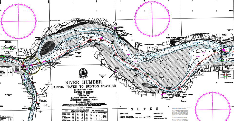
I do use a paper chart for the Humber above the Humber bridge as no electronic chart exists except for the marks on shore.
But I transfer the coordinates for the floats to my plotter a short while before travel.
This water is surveyed almost continuously and new charts issued every 2 months. The channel can move quite a bit or not much for reasons only known to nature
Thankfully the shallow puddle known as The North Sea has no rocks . The wind turbines are easy to see without a chart.
At Wells Next the sea the route into the harbour from the outer Cardinal is considerably adrift from the electronic chart and there is no paper chart . Only a video on the harbour website.
https://youtu.be/jzCvVZlrmWg
-

MartynG - Warrant Officer

- Posts: 237
- Joined: 31 Oct 2015, 17:41
- Location: The Planet Earth
I love charts - the tactile element is great, but being able to sit and work out all the little anomalies of an area is just cool (to me anyway
Absolutely agree.
I do use a paper chart for the Humber above the Humber bridge as no electronic chart exists except for the marks on shore
I'm not surprised, they would be printing thousands. I watched a video about the estuary a while ago and seeing how much dried out and the shifting sand banks would to say the least make the approaches a tad anxious. It's a larger scale version of Christchurch Harbour approaches, the shifting sands catch out quite a few yachtsmen and the lifeboat often has to sort them out.
I saw a programme a few years back about Dogger the sandbank out in the North Sea, I hadn't realised it was the land connecting the UK to Europe before the last Ice Age, no wonder it's shallow.
Loved the video of Wells next the Sea, very similar approaches.
- Ianfs
- Captain
- Posts: 2060
- Joined: 24 Nov 2014, 18:40
- Location: Hampshire, by the Sea
The Humber is a good training ground but not so bad once you get to know it. The floats and marks are large.Even with experience you do have to do your research in advance of a journey.
Boats do go aground quite often as the water all looks the same even when it is only inches deep. On one occasion, a few years ago, motor boat hit one of the floats and it ripped the side out of the boat.
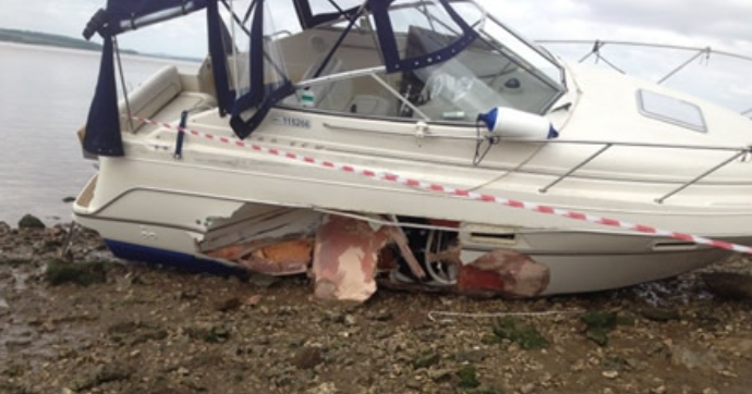
Boats do go aground quite often as the water all looks the same even when it is only inches deep. On one occasion, a few years ago, motor boat hit one of the floats and it ripped the side out of the boat.
-
MartynG - Warrant Officer
- Posts: 237
- Joined: 31 Oct 2015, 17:41
- Location: The Planet Earth
13 posts
• Page 1 of 2 • 1, 2
- View new posts
- View unanswered posts
- Who is online
- Re: An end to boating by ian h
- An end to boating by argonaut
- Changing Trailer bearings by argonaut
- Re: Refresh to Dash Project by argonaut
- Re: Refresh to Dash Project by Ianfs
- Refresh to Dash Project by argonaut
- Re: Boat Brokers by argonaut
- Re: Boat Brokers by Cap'n Jack
- Re: Boat Brokers by argonaut
- Shop Inboard & Outboard Boat Motors in UK at Sal marine by Salmarine
- Changing Trailer bearings by argonaut
- Shop Inboard & Outboard Boat Motors in UK at Sal marine by Salmarine
- Wind by MartynG
- Cleaning teak by MartynG
- Smith and Allan 75w-90 FS Gear oil by MartynG
- Mannol Diesel Fuel Additive by MartynG
- Fletcher Boats by ian h
- Trailer Brakes by argonaut
- Sharrow Prop by argonaut
- Boat ID by DavyD
- Maritime 21 by Gecko2
- After the disaster of last year... by Doc Oakley
- JOBE boat mirror by argonaut
- Buys Ballots Law by Ianfs
- Can't wait for Summer ? by argonaut
- Auto Drive on hook up by argonaut
- In total there is 1 user online :: 0 registered, 0 hidden and 1 guest (based on users active over the past 5 minutes)
- Most users ever online was 5791 on 02 Jul 2026, 22:51
- Users browsing this forum: No registered users and 1 guest